

About Vernon


At the geographic and economic center of the North Okanagan, between the shores of 3 lakes is the city of Vernon, BC
Home to beautiful views and so many outdoor activities - from golf to sailing to cycling to skiing and so much more - it's a community rich with spirit and art and expanding to meet the needs of North Okanagan.


The City of Vernon is divided into many areas that vary in character and features. If you're new to town, I can help you choose the areas that are a best fit for you.
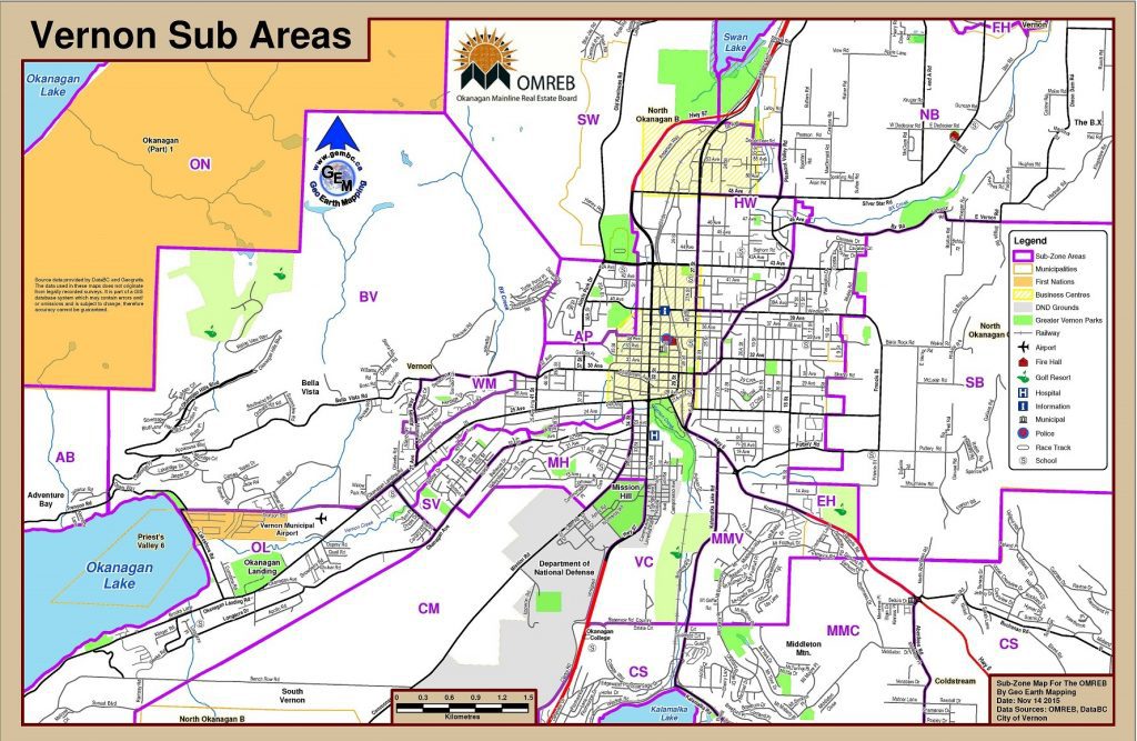
Okanagan North
The area north of the Fintry Delta on the west side of Okanagan Lake around Head of the Lake
Bella Vista
Properties west of Agnew Road to where Bella Vista Road connects to Tronson Road, south to Tronson Road and Okanagan Landing Road to Allenby Road
Adventure Bay
Properties located from where Bella Vista Road connects to Tronson Road to Canadian Lakeview Estates and the Tavistock subdivision
Okanagan Landing
The northwest flank of the Ellison Ridge along the east shore of Okanagan Lake including Ellison Park and Okanagan Landing to the southwest boundary of the old City of Vernon
Commonage
The area east of Ellison Ridge to Hwy 97 (except Clerke Road area) and south from Commonage Place to Kekuli Bay Park, excluding Predator Ridge
Westmount
The area between Bella Vista Drive and 27th Avenue, west of a line north from 43rd Street to Allenby and Richfield
South Vernon
The area between Okanagan Avenue and Vernon Creek, south from 43A Street to Graham Park
Mission Hill
The area bounded by 34th Street, the south side of Vernon Creek, along Okanagan Avenue to Bellevue Drive and south to the Commonage
Vernon City
The remainder of the City of Vernon excepting the above-mentioned sub-area and Okanagan Landing
Middleton Mountain (Vernon)
Middleton Mountain is the area West of Aberdeen Road, North of Kalamalka Road, East of Kalamalka Lake Road, and South of Highway 6
East Hill
The area east of Pleasant Valley Road, north of Hwy 6 to BX Road and Silver Star Road and east to the eastern boundary of the City of Vernon including Hillview Golf Course area. Also includes the area east of 27th Street and south of 30th Avenue
Harwood
The area bounded by 27th Street to the overpass, 39th Avenue, Pleasant Valley Road to Silver Star Road and the North BX boundary
Alexis Park
The area west of 34th Street to the base of the hill and from 35th Avenue to 43rd Avenue
Swan Lake West
The area west of Swan Lake, north of the City of Vernon, east of IR#1 and south of Hwy 97
North BX
Properties up-to-but-not-including Silver Star Resort (SS), west to Swan Lake, north to Spallumcheen and south to BX Road, excluding Foothills (FH)
South BX
The area east of the Vernon City limits, south from BX Road to Hwy 6, including that portion of the Sarsons area not in Coldstream
Foothills
Properties in the Foothills, Country Springs and Manning Place subdivisions
Municipality of Coldstream
The portion of the District Municipality of Coldstream from Hwy 97, Middleton Mountain and Cosens Bay, east to Ricardo Road
